

Weather Buoy Builders
NOAA's PMEL scientists predict our weather future and keep us safe.


Inside NOAA’s Seattle lab that watches the Pacific breathe
One blindingly bright Monday in Seattle, lightning canceled a Chicago Cubs road game in New York. It was the second cancellation in two days — the Cubs had already been rained out in Chicago on Father’s Day. Nobody at the ballpark thought to thank a federal ocean lab on the shore of Lake Washington, but they probably should have.
Local weather data helps forecasters warn us about lightning and rain. NOAA climate trackers predict the future. The building I visited that morning: NOAA’s Pacific Marine Environmental Laboratory (PMEL) is known to the people who work there simply as Building 3. NOAA Labs study Ocean data necessary for forecasters to predict climate for more than a week. Including next winter!
Building 3 sits on NOAA’s Western Regional Center campus, a low cluster of structures stair-stepped along Sand Point Way, looking out at Lake Washington. Inside, scientists and engineers build, test, and recalibrate the ocean buoys that make up one of the more quietly essential pieces of climate infrastructure on Earth. I met Dr. Meghan Cronin, a NOAA oceanographer, along with summer interns Tingting (grad school at University of Tokyo) and Carlos (undergrad at Bates College) for a tour through labs, storage bays, and what amounted to a buoy repair shop: workbenches, spare sensors, and buoys in various stages of undress. An older buoy retrieved from a year adrift in the open ocean waited to be cleaned of biology, recalibrated for precision, and sent back out to monitor weather to keep people safe.
Monitoring global climate predicts weather beyond a week to ten days, even the upcoming seasons. Ocean information is absolutely key to predicting that 2026 will have strong El Niño winter; milder temperature, variable snowfall, longer cold snaps, drought, flooding. PMEL scientists predict long term climate, and; earthquakes, tsunamis, and marine ecosystems.
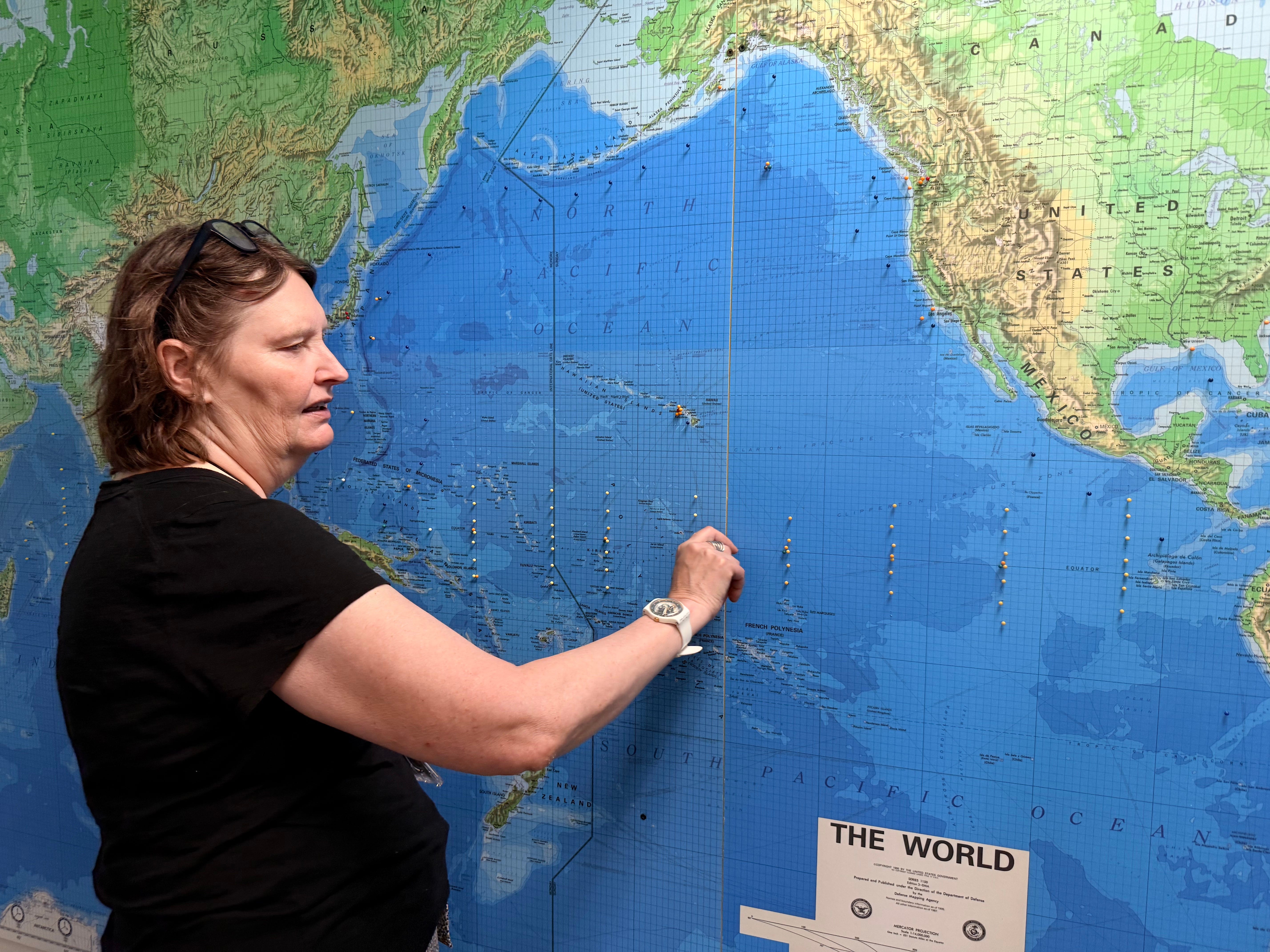
A network three-hundred buoys wide
The lab’s buoys are scattered by the hundreds across the tropical Pacific, Atlantic, and Indian Oceans. Buoys are anchored to the seafloor by lines that, in the Pacific array, run for thousands of meters down to knotted-railroad-tie anchors on the sea bottom. Each one carries instruments that log sea and air temperature, wind speed and direction, barometric pressure, humidity, and rainfall. Buoys beams the readings up to satellites in real time.
Many older repeatedly refurbished buoys were given short radio call-sign names; Mike (M), Bravo (B), Papa (P), a practical alphabet for keeping hundreds of moorings organized. Few remain. The only one remaining from those Ocean Weather Ship days that still builds ocean and atmosphere time series is Papa. That buoy was hauled in and freshly scraped clean of barnacles and algae the day I visited. Papa moors far out in the North Pacific, where a persistent-high-pressure system builds.
Nowadays, they give ocean stations acronyms like the deep-sea monitoring KEO for Kuroshio Extension Observatory. NOAA’s KEO monitored the deep sea warm water conveyor belt. KEO was decommissioned this spring due to pricey research-ship budget cuts.
The Tropical Atmosphere Ocean array (TAO), part of Japan’s Agency for Marine-Earth Science and Technology (JAMSTEC), took over the buoys well west (165 E) of the international date line to near the Galapagos in an ongoing five-year bilateral project with NOAA. The United States and Japan formally renew their agreement to keep it running. Dr. Cronin mentioned, almost in passing, that she had a planning meeting for the next MOU (Memorandum of Understanding) renewal of JAMSTEC and NOAA right after our tour. Around the Pacific Rim, they will collaborate for Ocean observations, research, and modeling.
The ocean monitoring array exists because of El Niño. Peruvian fishermen noticed warm water arriving around Christmas as early as the 19th century and called it El Niño, after the Christ child. Decades later, in the 1920s, the British scientist Gilbert Walker identified a seesaw in atmospheric pressure across the Pacific — what’s now called the Southern Oscillation. By 1960, researchers had linked the two phenomena and coined the term ENSO, for El Niño–Southern Oscillation. But the event that actually built the modern observing system was the El Niño of 1982–83, an event so powerful and so poorly anticipated that it pushed the international Tropical Ocean–Global Atmosphere program, TOGA, to fund a real-time network of moored buoys across the equatorial Pacific. That network became TAO. By the time the famous 1997–98 El Niño arrived, scientists had a working system in place to watch it unfold — and to warn the people in its path.
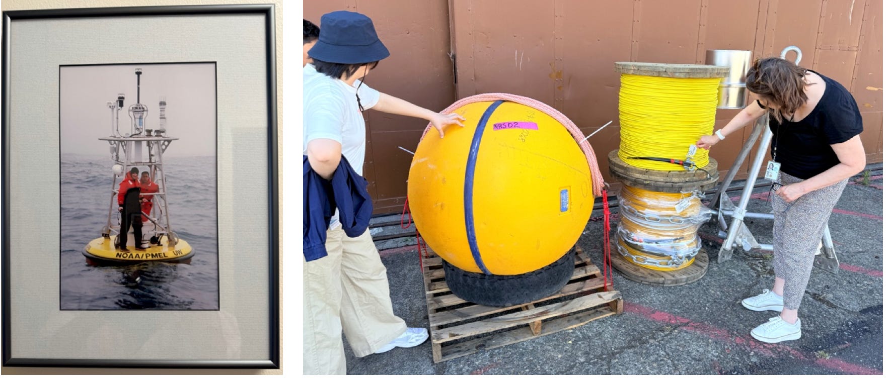
Monitoring Buoy at Sea Deep Sea Monitoring cables and a float.
Today the NOAA PMEL lab tracks sea-surface temperature across the central and eastern tropical Pacific, including a specific patch of ocean called the Niño 3.4 region, in the central equatorial Pacific. Warming at Niño 3.4 is one of the most reliable early indicators of a coming El Niño weather pattern. Kelvin waves, slow swells of warm water that move eastward hundreds of meters below the surface, can give scientists three to six months of warning before the effects reach the surface and the atmosphere. Combine that subsurface signal with surface buoys, autonomous wave gliders and sail drones, research ships, and satellites, and you get a system that can flag droughts, floods, atmospheric rivers, hurricanes, and the kind of lightning that cancels a baseball game. Often well in advance.
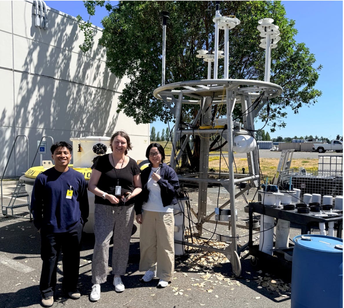
Papa being refurbished to return to monitoring with Carlos, Dr Cronin, and Tingting
A question that wouldn’t resolve
Not everything the buoys send back fits the textbook picture. Walking through the lab, Tingting raised a puzzle she’d been pondering involving TAO, a NOAA buoy moored in offshore of the warm Kuroshio current (the North Pacific Gulf Stream). The normal balance between evaporation and rainfall there seemed to be breaking down. Hydrological cycle = water cycle theory, or, sunlight warming the ocean surface, some of that water evaporates, the evaporation itself cools the sea. The resulting moisture, buoyant air, rises vertically to form clouds that eventually drift to cooler regions and release their water as rain. This cycle helps regulate the planet’s temperature. But the data near that buoy showed less evaporation paired with more precipitation than the cycle would predict.
Dr. Cronin’s instinct was to look upwind. What kind of air mass was arriving at the buoy? And from where? She explained, “Dry desert air sweeping out over the Pacific and meeting a warm current can be very effective at evaporation, and then transporting the moisture away before it precipitates.” It’s the kind of thing that looks like a contradiction in a spreadsheet and turns out to be a clue about atmospheric transport once you ask what’s blowing in from somewhere
Watching the ocean breathe carbon
Building 3 also houses a long-running ocean acidification program, which tracks how the Pacific is absorbing carbon dioxide through four linked measurements: 1) the partial pressure of CO₂ at the sea surface, 2) pH, 3) dissolved inorganic carbon, and 4) alkalinity. Together they describe how the ocean’s chemistry shifts as it takes in more carbon. Marine plants — phytoplankton, kelp, seagrasses — use that carbon dioxide and sunlight to photosynthesize, splitting water and releasing oxygen as a byproduct. Collectively, ocean plant life is responsible for making roughly half of the oxygen in Earth’s atmosphere. Coastal ecosystems like mangroves, salt marshes, seagrass meadows, and coral reefs also act as long-term carbon sinks, locking carbon away in sediment and rock for centuries. Watching how that storage capacity changes is, in its own way, as important to the lab’s mission as watching for the next El Niño.
An old habit, getting more capable
The instinct to keep careful ocean records in the United States goes back further than most people would guess — Thomas Jefferson was an early advocate for systematic observation of the seas. What’s changed since is the technology doing the watching: autonomous wave gliders and sail drones can now patrol the ocean for a year at a stretch, gathering the kind of data that used to require a ship and a crew, before returning to a building like this one to be cleaned, repaired, and sent back out. Increasingly, machine learning tools are being used to comb through the resulting flood of measurements for patterns a human analyst might take months to find.
I left the lab and stepped back out into that bright Seattle morning thinking less about the Cubs — though I did feel for the fans in New York — and more about how much quiet, continuous infrastructure sits behind a single line of long term climate predictions envisioning the future of next winter’s forecast. Three hundred buoys, a fleet of autonomous gliders, decades of partnership with Japanese researchers, and a building full of people who scrape barnacles off sensors so the rest of us can decide whether to bring an umbrella, evacuate ahead of a hurricane, or call off a ballgame before the lightning arrives. It’s not the kind of science that makes headlines very often. It’s the kind that’s silently working in the background every time the headlines don’t have to.
To Be or Not to Be? That is the Question.
The administration’s FY2026 budget proposals repeatedly sought to gut the observing systems that make weather and ocean climate forecasting possible. At various points targeting NOAA’s research arm entirely, the regional buoy networks under the Integrated Ocean Observing System, and even naming PMEL itself, the Seattle lab in Building 3, for closure. Congress ultimately passed full-year FY2026 appropriations in January 2026 providing $6.1 billion for NOAA, $1.6 billion more than the administration had requested — meaning lawmakers restored most of what the White House tried to cut, at least for that budget year. But “restored” doesn’t mean “whole”: the regional ocean-observing program has been chronically underfunded for years regardless of administration, requiring an estimated $715 million to fully deliver on its mandate but never receiving more than $42.5 million. Separately, the National Science Foundation moved this spring to dismantle most of the Ocean Observatories Initiative, a $386-million sensor network off the West Coast and Northeast, with buoys already being pulled from the water in June. Congress, across party lines, pushed back hard enough to keep NOAA’s core buoy and ship operations funded for now. Parts of the broader ocean-observing ecosystem are still being cut or left to wither from underfunding. It’s an unresolved battle, not a finished one. https://www.congress.gov/crs-product/IF13024
Dr. Meghan Cronin and her NOAA team observe climate in a partnership with UNESCO’s Ocean Decade OASIS Programme: https://airseaobs.org/projects-linked-to-oasis
Anam Cara Eco-Art Space, an Ocean Decade Project in the Midwest, is linked to the OASIS Programme.
For More Information on Climate Change Data please visit: https://www.climate.us